The countryside around the villages offers a wealth of public footpaths and bridleways. We will over the coming months publish a range of circular walks and cycle rides that will offer a mixture of easy and challenging routes. Some will be based on Barwick in Elmet whilst others are starting in Scholes.
Please remember when out and about to follow the Countryside Code
1. Circular Route from Barwick to Aberford via Parlington 9.8 miles
Our thanks to http://happyhiker.co.uk/MyWalks/WestYorkshire/Barwick-in-ElmetCircular/

Introduction: This is an ideal walk for anyone wanting something of respectable length but almost wholly flat, as it follows well defined bridle paths and course of old railway tracks. It starts at the maypole standing some at 86 feet high.
The walk passes through Aberford where there are a couple of pubs, notably the Arabian Horse, for refreshments.
Parking is a case of finding an on street spot. As a
common reference point, the walk starts at the maypole which is by the Gascoigne Arms in the centre of the village.
Start: With your back to the maypole (SE 340375) and the Gascoigne Arms on your right, proceed along Main Street. Turn right on Carrfield Road. Cross over Elmwood Lane staying on Carrfield Road which eventually continues as a broad rough track, the public right of way being indicated by a fingerpost.
At a metal kissing gate, turn right to follow the hedge line.
At the next gateway, turn left to follow the direction of the yellow footpath arrow. On reaching the road on the outskirts of Scholes (SE 383365), turn left and first right on to Leeds Road. Immediately after turning, take the track on the left signposted Public Bridleway and
bearing an owl motif, indicating this section is part of the Leeds Country Way.
When the track splits at a four way fingerpost, turn left remaining on the public bridleway. The track follows the outside of a small wood. Ignore a broad track on the left and pass the barrier which says “Authorised Vehicles Only”.
Ignore a footpath on the left.
When the path splits, bear left.
At a crossroad of tracks (SE 388350), turn left. Stay on the main track straight ahead through the golf course, ignoring any turns off and come out past a farm. Stay on the farm track to the road and cross over heading for Throstle Nest Farm. As you get to the farm (SE 409357), branch off to the right where you enter the Parlington Estate (Parlington Hall now demolished).
Keep straight ahead at two cottages.
Pass a fishing lake on the right (SE 421358) and shortly after this, when the track forks take the right fork indicated by a metal bridleway sign. At the old railway tunnel, you have the option to go through it or divert round the track to the right hand side. The tunnel can be very muddy and at the time of my visit, there was great danger of treading on frogs! There is a second small tunnel too. Parlington’s Triumphal Arch appears on the horizon after the tunnels.
You will also come across a tree with an unusual configuration, known as Nellie’s Tree. This was a deliberate cultivation by a man called Vic Stead a hundred years or so ago. He grafted a sapling between two others, to form the shape of a letter ‘N’, to woo his love! Locals also know it as the Love Tree.
It won England’s Tree of the Year in 2018, in a competition organised by the Woodland Trust.

Pass the old lodge house to Parlington Hall which is Grade II listed.
On reaching the road (SE 433369) on the outskirts of Aberford, turn left, and walk into the village. Just past
the Arabian Horse pub, turn left on Becca Lane (SE 434375). It is along here where you might make out the ancient earthworks, Becca Banks, amongst the trees. When the track forks, the right hand arm heading to a house, keep left.
As you approach Becca Hall , take a left turn (SE 422385) and shortly afterwards, is a three way fingerpost.
Take the direction of “Public Bridleway Leading to York Road”.
Follow it alongside a wood then a section of field to a gate and then a hawthorn hedge on the left.
Just past Becca Home Farm , look out for the left turn across a field (SE 416389). There is a finger post but the angles of the arms were a little deceptive when I visited. Part way across the field is a post with a yellow diamond confirming the route and when I visited (2012) there was a tree in the middle of the field which makes a good point to aim for. From the tree head turn right and head for the right hand corner of the copse of trees (SE 412390).
A post with a yellow top confirms the route.
Follow the edge of the trees on your left and as they finish, follow the hedge on the left to another footpath
indicator post. Follow the field edge. The path exits the field and turns left round another field.
As you pass the next copse of trees, cross a plank bridge over a stream then a stile (SE 407393) and follow the path across the field to the marker post at the road. Turn left and walk along the road back to Barwick-in-Elmet, going left at the ‘T’ junction to return to the maypole.

Walk 2 is taken from a booklet of walks around the parish written by Alan Senior in the 1990’s. Our thanks to Mrs E. Senior for allowing publication here.
Being a circular walk you can join at several points in either village.
The Maypole at Barwick OR Scholes Cricket Club
Walk towards the Chapel and go along Elmwood Lane as it bends to the left, then shortly turn right into Elmwood Avenue.
Walk along the right hand side pavement to a narrow ginnel between Nos. 30 and 32. Continue along the ginnel, turn right at the hedge and walk down a steep slope.
After passing through a small lift-up gateon the left descend along a crossfield path and pass through a gap, leading into Rakehill Road.
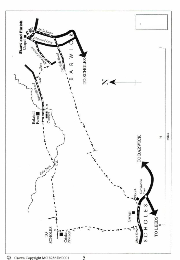
Now turn left and walk along the roadside until the road narrows over a cartbridge which crosses Rake Beck. Walk forward, with a farm on the right and a row of cottages on the left. (These cottages previously formed part of the Barwick Workhouse).
After crossing this stile walk for 40 yds. Continue upwards along a grassy track (very muddy in Winter) which meanders along a well defined route and which shortly recrosses the Rake Beck by a cartbridge.
After crossing the bridge walk up a steep slope and again follow the
meandering track to reach a footpath sign, adjacent to the Scholes Cricket Club pavilion. Pass through the kissing gate and walk on along a playing field area, keeping a hedge to the left. Cross the next stile and walk along a well defined path between open fields, to another stile leading into a further field. Now bear right to a stile and then continue, keeping first a fence and then a continue, keeping first a fence and then a which leads into a farmyard. A further stile leads from the farmyard into a narrow ginnel and the path continues on to Main Street, Scholes. Turn left and walk along the left hand side pavement.
Shortly after passing a garage on the left, turn left along a farm track which runs parallel to a semi-detached house, (No.24 Main Street).
Follow this track, keeping the hedge on the left, until it “peters out” and then walk along a footpath, now keeping a hedge on the right, to reach a ladder stile in the field corner.
After crossing this stile walk for 40 yds. and turn left to cross a stile into another field. Now keep a hedge on the left and at the end of this field ( ignoring a track on the right which is not a public footpath) “side-step” to the left into the adjoining field and then continue, now keeping a hedge on the right.
Follow the footpath, which soon changes into a farm track and, after passing long back gardens of a terrace of houses, walk into Carrfield Road and then, after crossing Elmwood Lane, to Main Street, Barwick. Turn left to the finishing point.